


PRECINCT BVT 4, Mahoning County, Ohio
About
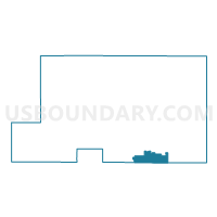
Outline

Summary
| Unique Area Identifier | 649680 |
| Name | PRECINCT BVT 4 |
| County | Mahoning County |
| State | Ohio |
| Area (square miles) | 6.58 |
| Land Area (square miles) | 6.20 |
| Water Area (square miles) | 0.37 |
| % of Land Area | 94.35 |
| % of Water Area | 5.65 |
| Latitude of the Internal Point | 40.90971480 |
| Longtitude of the Internal Point | -80.68072210 |
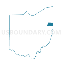
Maps

Graphs
Select a template below for downloading or customizing gragh for PRECINCT BVT 4, Mahoning County, Ohio


Neighbors
Neighoring Voting District (by Name) Neighboring Voting District on the Map
- Voting District COLUMBIANA VIL A, Columbiana County, OH
- Voting District COLUMBIANA VIL D, Columbiana County, OH
- Voting District FAIRFIELD TWP NORTH, Columbiana County, OH
- PRECINCT BVT 1, Mahoning County, OH
- PRECINCT BVT 3, Mahoning County, OH
- PRECINCT BVT 6, Mahoning County, OH
- PRECINCT SPT 3, Mahoning County, OH
- Voting District UNITY TWP NORTH, Columbiana County, OH
Top 10 Neighboring County Subdivision (by Population) Neighboring County Subdivision on the Map
- Unity township, Columbiana County, OH (9,957)
- Fairfield township, Columbiana County, OH (9,890)
- Beaver township, Mahoning County, OH (6,711)
- Springfield township, Mahoning County, OH (6,703)
- Fairfield township, Mahoning County, OH (666)
Top 10 Neighboring Place (by Population) Neighboring Place on the Map
Top 10 Neighboring Unified School District (by Population) Neighboring Unified School District on the Map
- East Palestine City School District, OH (8,285)
- Columbiana Exempted Village School District, OH (7,862)
- South Range Local School District, OH (7,289)
- Crestview Local School District, OH (5,898)
Top 10 Neighboring State Legislative District Lower Chamber (by Population) Neighboring State Legislative District Lower Chamber on the Map
Top 10 Neighboring State Legislative District Upper Chamber (by Population) Neighboring State Legislative District Upper Chamber on the Map
Top 10 Neighboring 111th Congressional District (by Population) Neighboring 111th Congressional District on the Map
Top 10 Neighboring Census Tract (by Population) Neighboring Census Tract on the Map
- Census Tract 8136, Mahoning County, OH (8,324)
- Census Tract 8135, Mahoning County, OH (7,377)
- Census Tract 9501, Columbiana County, OH (5,712)
- Census Tract 9503, Columbiana County, OH (5,100)
- Census Tract 9502, Columbiana County, OH (4,741)